Kicking off with a bold flourish, Φ-week 2021 promises to bring space even closer to the forefront of addressing society’s biggest challenges, namely issues associated with the climate crisis, while boosting the economy through transformative New Space, artificial intelligence, and quantum and cognitive computing.
ESA’s Φ-week is now in its fourth edition, and each year this forward-looking event is increasingly relevant to society, business and the economy.
In his opening address, Josef Aschbacher, ESA’s Director General said, “Europe faces unprecedented societal, economic, and security challenges. Space has enormous untapped potential to play in tackling pressing current and future crises, while simultaneously providing new impulse for the European space sector. We need to develop smart, automated services and applications to protect lives of people and to increase the protection of assets and natural resources.”
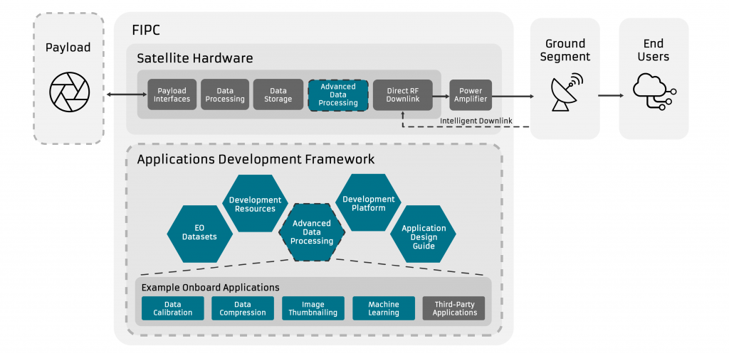
Timed to coincide with this year’s Φ-week event, ESA InCubed and Surrey Satellite Technology Ltd (SSTL) have announced a new initiative to design and test a high-throughput payload downlink chain for small Earth observation satellites. The module aims to provide data processing and transfer capabilities that are future-proofed for tomorrow’s onboard imagers.
Current and even more future satellite imaging payloads are generating multi-dimensional, high-volume data that can exceed the throughput capacity of small satellites. To tackle this data bottleneck, a consortium of the University of Surrey, Craft Prospect Limited and SSTL has been formed to develop product enhancements for the latter’s Flexible & Intelligent Payload Chain (FIPC) solution.
The advanced hardware architecture of SSTL’S FIPC will provide the basis for a new intelligent and adaptive data downlink, along with a state-of-the-art framework for software-defined data processing onboard the satellite. Processing tasks may include data calibration, data compression, image thumbnailing and Machine Learning (ML) for image classification.
SSTL Managing Director Phil Brownnett set out the vision for the leading-edge payload chain: “The FIPC solution will significantly improve the capabilities of small Earth observation satellites by increasing data rates to match the capacity of the onboard imager system. This will boost both the volume and complexity of the data that can be downlinked on a single satellite pass – a step up in performance that will match our customers’ business plans and ambitions.”
SSTL, Craft Prospect Limited and the University of Surrey will work together on the FIPC solution and onboard processing applications. Following the design phases, the consortium will demonstrate and evaluate the unit’s features on a flight-representative testbed.
Carlos Urbina Ortega, ESA Technical Officer for the activity, sees a number of advantages to be gained from the FIPC: “We envisage substantial benefits from this InCubed investment, not least because of the system flexibility and computational power that the FIPC affords. Capabilities such as onboard ML acceleration for enhanced data management and services, together with in-orbit application reconfiguration, will ensure that small-satellite missions remain agile and end-user focused.”
Focusing on the New Space economy and innovations in Earth observation, ESA’s fourth Φ-week kicks off on Monday 11 October. Join us live for two of the main sessions: the Opening session on Monday at 10:30 CEST and the Blending New Space Technologies and Services session on Tuesday at 16:00 CEST.
As the world starts to return to normality in the wake of the COVID pandemic, this year’s Φ-week is a hybrid event, with registered participants attending virtually and invited speakers present at ESA’s Centre for Earth Observation in Italy.
However, part of this not-to-be-missed event can be enjoyed by all – simply tune into ESA’s Web TV and following the live transmission links.
Mayday.ai GmbH will launch a new AI-automated platform in Europe developed with the support of the ESA InCubed programme and the German Aerospace Centre (DLR) for its next-generation disaster and risk information services.
Mayday.ai GmbH will deliver a centralised and AI-based platform providing real time and near real time disaster and risk information services. This German-based start-up provides early warning and (geostationary, polar), camera imagery, audio as well as social media sentiment analysis.
The solution, which runs on an agnostic AI fusion engine, will be available for government agencies, international organisations, first responders, insurance and utility for up to 18 disaster types with native language support.
Mayday.ai’s proposal was selected under the ESA’s programme InCubed Investing in Industrial Innovation with the support of the German Aerospace Centre (DLR), and was kicked-off in July 2021.
The development aims at further enhancing Mayday.ai’s disaster management platform and adapting it to the European setting and its neighbouring regions. It also supports the development of additional disaster management products as well as accelerating Mayday.ai’s global expansion.
“We are delighted that ESA and DLR have recognised our technological edge and potential, and grateful for their continuing support in our global growth out of Europe as we build our platform on the Sendai Framework principles. Our innovations will cater to the nuanced community needs globally, with the support of a community-owned model, as well as scenario-based automated notifications. Climate resiliency is within reach in case of many disasters with a culture shift towards proactive prevention, as opposed to the currently fragmented and highly reactive one. More importantly, in addition to saving lives, property, cultural and natural heritage, it also costs remarkably less to accomplish” states Mayday.ai’s Founder and CEO, Kian Mirshahi.
Bertrand Le Saux, ESA Technical Officer, added: “The Mayday.ai platformwill provide a next-generation, centralised solution to organise a timely and coordinated response to natural hazards. It will leverage real-time satellite imagery and AI-enhanced predictive analytics to provide automated detection, early warning and integrated two-way communication services for various types of incidents.”
After a number of successful global pilots, the Mayday.ai team will be releasing its enterprise version of its platform in a partnership with Esri, the Environmental Systems Research Institute. In autumn 2021, the company aims to officially launch its efforts to boost community-based resiliency through various global campaigns.
More information on Mayday.ai GmbH InCubed activity can be found here.
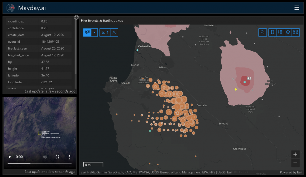
Mayday.ai Real Time Disaster Information Web based Platform in Esri.
Are you a Danish start-up or company working in Earth observation and using satellite data? Apply now for the InCubed Denmark call here. The deadline is 22 August.
InCubed stands for ‘Investing in Industrial Innovation’ and is a Public Private Partnership co-funding programme run by the ESA Φ-lab that focuses on developing innovative and commercially viable products and services that exploit the value of Earth observation imagery and datasets. InCubed has a very wide scope and can be used to co-fund anything from building satellites to ground applications and everything in between as well as the development of new EO business models.
The programme works in very close cooperation with its participating Member States and can issue dedicated country-oriented calls as the one just published for Denmark.
In 2021, Danish companies and commercially focused research institutions can apply for up to 3.4 million Danish Kroner in co-funding for the development of innovative and commercially sustainable technology, products and services using Earth observation data through ESA’s InCubed programme.
The call and application form are available online on: link.
The deadline for submitting project pitches to ESA and the Danish Agency for Science and Higher Education is Sunday 22 August.
Idea pitches and proposals are assessed by the Danish Agency in an open competition, based on specific criteria including growth and competitiveness, level of innovation and societal impact. Once evaluated, successful applicants will receive a Letter of Support, which is required to finalize the application process with ESA.
Read more about the national process at the Danish Agency for Science and Higher Education website.
With a project called FloodSENS, the Luxembourg-based company RSS-Hydro is now part of ESA’s InCubed programme. The project aims to develop an algorithm that efficiently identifies flooded areas under partial cloud coverage in optical satellite images, using Machine Learning and auxiliary high-resolution data from drones, digital elevation models, as well as water flow algorithms.
Floods are one of the most devastating natural disasters, accounting for the highest insured and uninsured losses annually, as well as costing many lives. The climate emergency intensifies the hydrological cycle. Consequently, the frequency and magnitude of extreme hydro-meteorological events, and therefore the risk of floods, are increasing, as confirmed to be happening in many places around the world. This flooding increase has devastating consequences, among which are a greater strain on humanitarian response efforts and the financial risk of the global (re)insurance market.
With the support of ESA InCubed programme, RSS-Hydro has now started to work on FloodSENS, a service that specifically addresses these issues by developing a flood mapping application for the open market that overcomes one of the major limitations of optical EO imagery during floods and is capable of efficiently scaling between optical satellite and drone images. Therefore this novel application would be able to efficiently reconstruct flooded areas under partial cloud cover in optical satellite images.
Guy Schumann, RSS-Hydro CEO, said: “This type of application is especially important for disaster response agencies at regional, national, and international level, who are keen to utilize the proliferation of open satellite data for flood mapping during emergencies. Additionally, in the insurance and re-insurance markets, stakeholders are interested in EO data to map the flood hazard of a high-impact event and, on a historical basis, to understand risk exposure and the changing nature of it.”
Bertrand Le Saux, ESA InCubed Technical Officer, added: “FloodSENS integrates both drone data and EO imagery with Machine Learning, to offer the best support to emergency response activities, as well as to the re-insurance market. At ESA, we see a big potential in this activity and we are ready to support it until its entry into the market”.
For Europe, but also for many other countries worldwide, future innovative EO-based and Machine Learning-powered apps would add considerable benefits to the existing products and services of the free Copernicus Emergency Management Service (EMS) and beyond. RSS-Hydro’s FloodSENS will position itself at the intersection of these two fields (EO technologies and Machine Learning application tools) and at the forefront of future EO-enabled innovative solutions, enabling a much more effective disaster response.
More information on the FloodSENS InCubed activity can be found here.
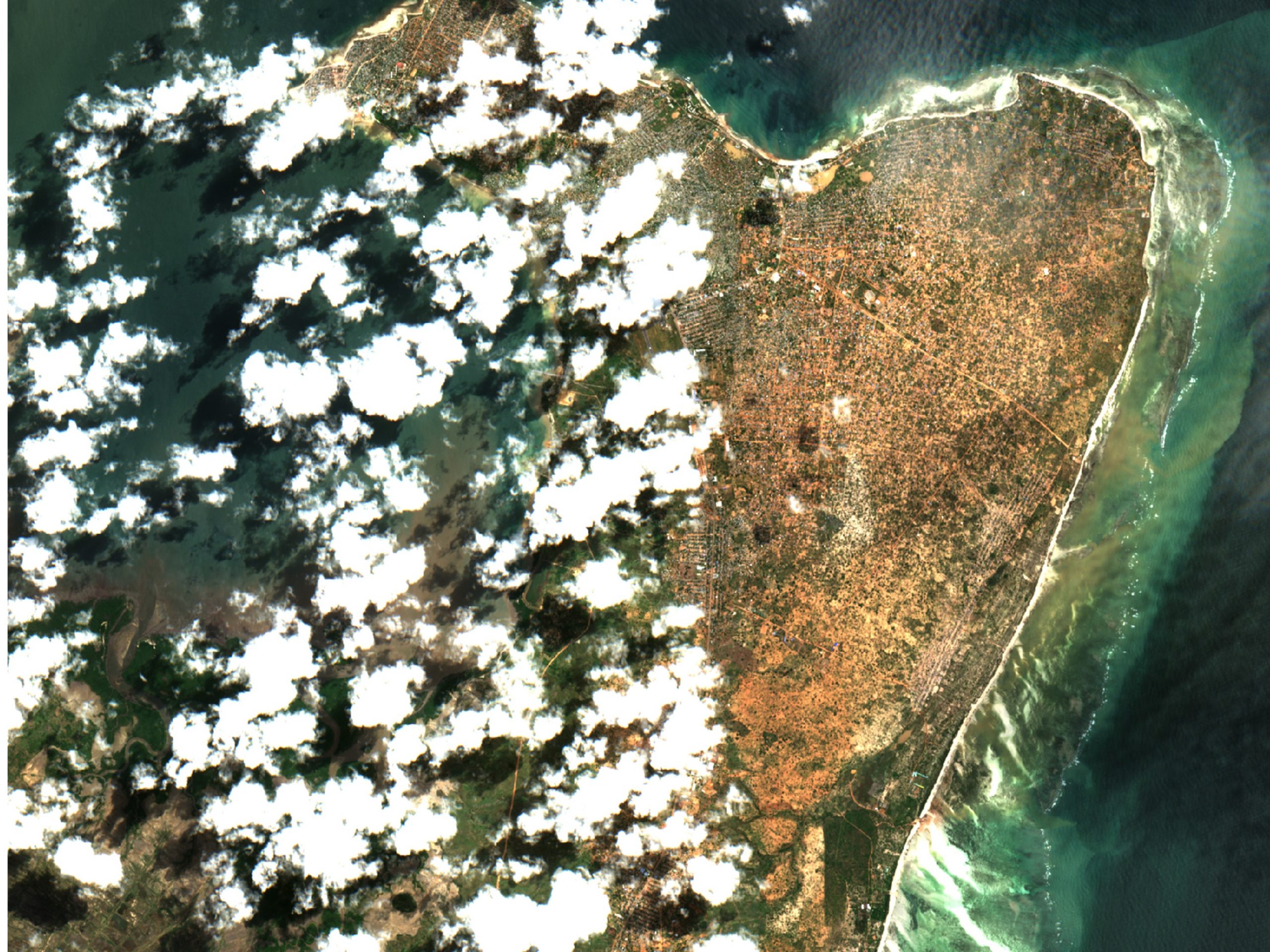
Image caption: The first half of 2019 was a devastating period for many countries in southeast Africa. After Cyclone Idai destroyed many places, in particular the port city of Beira, at the start of the year, Cyclone Kenneth ravaged northern Mozambique. Entire villages were destroyed and almost one million people were put at risk in the area. This partial cloud-free subset of a Sentinel-2 image from 3 May 2019 shows large areas under water in Pemba, regional capital of Cabo Delgado state, which experienced over 2 m of rain and flooding. FloodSENS will render optical imagery like this more usable during floods by reconstructing flooded areas under cloudy skies.
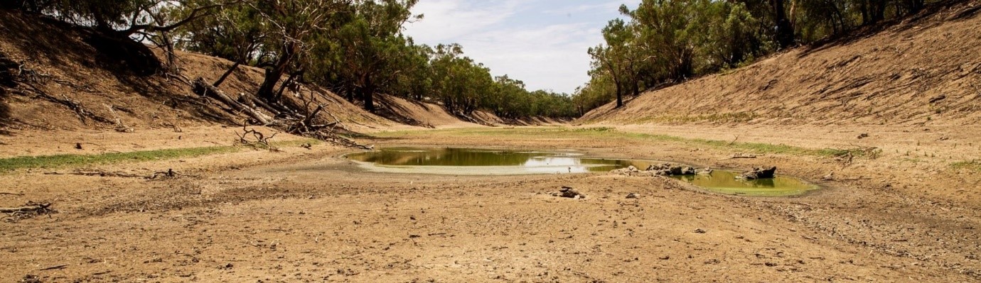
ESA’s InCubed programme is supporting the development and pilot implementation of FutureWater’s new InfoSequia module, dubbed 4CAST. InfoSequia-4CAST combines historical and up-to-date observations of satellite-based meteorological and agricultural drought indices with climate variability indices to generate seasonal outlooks of water supply and crop yield failure alerts.
Water and food security are at risk in many places around the world, at present and even more so in the future, with significant economic and humanitarian consequences. Risk managers and decision-makers, such as water management authorities and humanitarian-aid agencies, can more effectively prevent harmful drought impacts if timely and actionable information is available on how water and food availability is affected.
FutureWater, a Dutch SME specialist in water management solutions, is developing InfoSequia-4CAST to provide users with timely predictions on drought impacts on crop yield and water supply. Seasonal outlooks are computed by a novel, state-of-the-art Machine Learning technique, previously tested in applications for crop production forecasting and agricultural drought risk financing. The module responds to needs identified in previous applications and is a major extension of FutureWater’s Drought Early Warning and Forecasting System, InfoSequia. Another module, InfoSequia-MONITOR, is also being improved by incorporating satellite data to create multi-sensor drought indices.
Using multi-sensor, state-of-the art satellite data fully integrated with predictive models, InfoSequia-4CAST provides location-specific 3-6 month outlooks and warnings of crop yield and water supply failures to end users through a simple, intuitive user interface.
After signing the contract with ESA in February 2021, FutureWater Project Manager Gijs Simons said: “This ESA supported InCubed activity is a unique opportunity for FutureWater to transfer a highly promising technology from the academic domain to a market-ready, operational decision-support tool. We are very enthusiastic about collaborating with ESA and a range of regional stakeholders to realise this product, which we believe can make a crucial difference for water management authorities and humanitarian NGOs worldwide.”
FutureWater works with one of the world’s leading institutes in sustainability science, the Institute for Environmental Studies of the Free University of Amsterdam (IVM), to develop InfoSequia-4CAST. The product is targeted to the needs of water managers who intend to alleviate and mitigate the impacts of forthcoming drought periods by taking well-informed water management decisions, as well as humanitarian NGOs aiming to trigger ex-ante cash transfers with policyholders and farmer communities.
The InCubed activity includes collaborations with stakeholders and future end users in Spain, Colombia and Mozambique in order to establish user requirements, inform system design, and achieve pilot implementation of the system in the second project year.
Anna Burzykowska , ESA InCubed Technical Officer, added: ‘’The Earth Observation market sees an increased uptake of different type of products providing drought indices and early warning systems. The development of the FutureWater’s-4CAST module will enhance the current offering by producing advanced regional drought impact models with important improvements such as fusion with climate data records, yield forecasting as well as monthly and quarterly seasonal outlooks to more effectively manage the disaster impacts. We look forward to facilitating the project’s R&D activities as well as to supporting the engagement with new institutional and commercial customers.’’.
More information on the InfoSequia-4CAST InCubed activity can be found here.
The ESA Φ-lab and the InCubed programme will be presented, together with the Norwegian ESA BIC and the ESA BASS programme, at the Norway Industry Day that will be held on Tuesday 11 May.
All Norwegian companies working in the Earth Observation value chain – from satellites, systems, sub-systems to ground segments and the utilisation of space applications – are welcome to participate in the next Norway Industry Day, which will take place virtually on Tuesday 11 May, starting at 10 CET until 13.00 CET.
Giuseppe Borghi, Head of the Φ-lab, and Amanda Regan, Head of Φ-lab Invest Office, will give a general overview of the Φ-lab activities and opportunities and of the Investing in Industrial Innovation (InCubed) programme.
Rita Rinaldo, from the Downstream Business Applications Department of the Telecom and Integrated Applications Directorate, will present the ESA BASS programme together with representatives from the Norwegian ESA BIC with company examples.
Presentations will focus on the Norwegian space economy perspective.
Representatives of companies that are already part of InCubed will provide their experience of working with the Φ-lab and InCubed.
If your Norwegian company is interested in Earth observation and would like to attend the Industry Day, please contact Ville Meskus and Ole Morten Olsen.
TheESA Φ-lab and InCubed programme will be presented at the next Earth Science Information Partners Innovation (ESIP) Webinar to be held online on Wednesday 28 April, at 16:30 CEST.
The webinar shall focus on the Φ-lab and Investing in Industrial Innovation (InCubed Programme)
InCubed is a 100M euro open-call programme that focuses on developing innovative and commercially viable products and services to leverage the value of Earth observation data. This programme has a very wide scope and can be used to co-fund anything from building satellites to ground applications and everything in between or to develop new EO business models.
During the webinar, the InCubed Programme manager Amanda Regan shall provide an overall of the Φ-lab and the InCubed programme and four companies who are in the InCubed pipeline shall present their activities: Hyperscout-2, CoastEO, MANTIS, and SAT4FLOOD.
SuperVision Earth is a German start-up established in 2018 by the winners of that year’s local Copernicus Hackathon. Since then, the start-up has benefited greatly from the Copernicus Accelerator, Copernicus Incubator and ESA BIC programmes. This latest InCubed activity will develop SuperVision Space, an automated satellite-based monitoring solution for routine pipeline monitoring.
More than a million kilometres of high pressure pipelines, often buried underground, run through countries supplying gas and energy to businesses and communities worldwide. The pipelines are subject to various risks, such as third-party activities, vegetation and ground movement. Third-party activities, such as construction or digging close to pipelines, are the leading cause of incidents. An early and efficient detection of risks is necessary to minimise environment exposure and damage, natural gas explosions, loss of lives and carbon emissions. In addition, it could also save gas companies millions.
To address this issue, SuperVision Earth developed SuperVision Space (SVS) based on proprietary AI-powered software to analyse satellite data, detect and regularly report on various risks. ESA’s InCubed programme will co-fund SVS, support its development, and de-risk the activity by providing technical and programmatic support. As part of the programme, SuperVision Earth will also gain access to potential investors and networking opportunities through dedicated events and possible arrangements being explored in 2021.
Alongside ESA’s InCubed programme, SuperVision Earth has partnered with the energy and infrastructure companies Entega and Terranets. These partners have already conducted several pilot projects in the field of satellite-based pipeline monitoring.
The InCubed contract was signed and the kick-off meeting took place end of March 2021, attended by SuperVision Earth, Entega and Terranets, alongside representatives from ESA. Members of the German delegation, who backed this activity were also in attendance, alongside representatives from the German industry association DVGW, a standardisation body for the gas and water industry, who are supporting SuperVision Earth with their expertise.
On signing the InCubed contract, SuperVision Earth’s COO and co-founder Jan Kolmas said: ‘’We are honoured to be the first German company to sign a contract with ESA’s InCubed programme. This activity is essential to SuperVision Earth’s mission of making gas infrastructure more secure, with a positive impact on the reduction of CO2 emissions, increased competitiveness of the European EO and AI sectors, and generation of high-tech jobs in Europe.’’
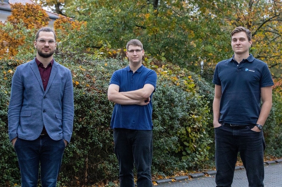
Left to right: Supervision Earth’s CEO Karsten Wiertz, CTO Sebastian Bussman, and COO Jan Kolmas
Satellite-based monitoring represents a useful addition to the toolbox of gas infrastructure operators, thanks to its low cost, its convenient frequency and its absence of carbon dioxide emissions. SuperVision Earth’s SVS downloads satellite images of pipeline corridors from providers around the world. These are analysed by an embedded AI model in order to detect potential threats. SVS then sends prompt warnings to the operator’s engineers, who use the product to make informed decisions, so preventing threats from becoming catastrophic incidents such as natural gas explosions, environmental damage and economic costs. More information on SVS can be found here.
Amanda Regan, InCubed programme manager, added: ‘’This activity offers an innovative solution aimed at gas and energy pipelines monitoring. This is the first German InCubed contract to be signed and we would like to thank both SuperVision Earth and the German Delegation. This is an innovative concept which will contribute to the overall European EO commercial landscape.’’