ESA title

InCubed-supported HyperScout imager selected for high-profile Australian CubeSat mission

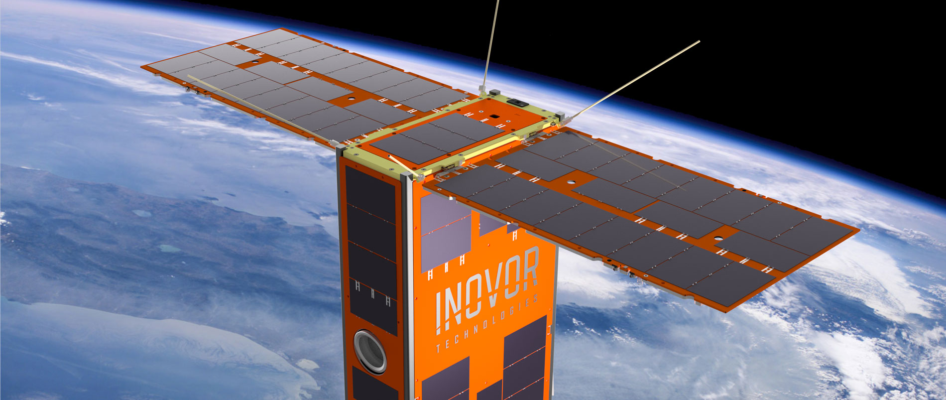
The HyperScout instrument, partly developed by cosine Remote Sensing under an ESA InCubed co-funding activity, has been adopted as the hyperspectral imager of choice for Australia’s first satellite mission funded at state level. Scheduled for launch in 2022, the Kanyini is based on a 6U CubeSat platform and is being engineered by SmartSat CRC and two South Australian companies.

The SASAT1 Kanyini project is aimed at promoting and developing the South Australian space industry through the launch of a CubeSat nanosatellite with Earth observation and Internet of Things (IoT) payloads. With funding from the South Australia state government, Kanyini is a collaboration between local entities the SmartSat Cooperative Research Centre, Myriota and Inovor Technologies.

Data collected from the project is intended to support informed decision making in the areas of water usage, climate policy and disaster management. There is also an associated educational programme, which commenced with a competition in schools to name the satellite itself. The winning entry, ‘Kanyini’, is a Pitjantjatjara aboriginal word that describes the principle of responsibility and unconditional love for all of creation.

The HyperScout 2 is a three-in-one instrument that combines hyperspectral and thermal imaging with high-level data processing and Artificial Intelligence (AI) capabilities. Available for deployment on satellites of any dimensions, the imager is however particularly suited to small platforms built around a smart blend of custom-made and commercial off-the-shelf (COTS) components. The HyperScout series was designed and brought to production by the Remote Sensing business unit of Dutch company cosine, with initial co-funding support provided by the Dutch government through the Φ-lab InCubed programme.

“We needed a compact imaging payload that gave us a much more nuanced Earth view than a three-band sensor,” explained Pete Nikoloff, Kanyini Mission Director at SmartSat. “The spectral range of the HyperScout 2 enables an extremely detailed analysis of land cover, benefitting research into crop health, forests, inland water and coasts, while the thermal infrared imager will provide vital information on heat generators in South Australia. In parallel with the development phase, a research programme is being formulated with SmartSat’s partners to make the best use of the systems once in orbit.”

cosine Remote Sensing Managing Director Marco Esposito underlined the AI credentials of the company’s brainchild: “The HyperScout 2’s onboard processing power will give Kanyini the opportunity to utilise advanced AI algorithms directly in orbit, ultimately reducing data traffic requirements or accelerating decision making for rapid-response scenarios.”

ESA Scout System Manager Massimiliano Pastena sees a crucial link with the ethos of the Φ-Department: “We’re very happy that HyperScout 2 has been selected for Kanyini, as it provides another example of an InCubed-supported initiative that subsequently grows and enjoys take-up at a global level. We also found the name of the satellite, with its reference to care and responsibility for our planet, an inspired choice that matches well with our approach to future Earth observation.”

“The purpose of the ESA InCubed Programme is to support and develop the commercial EO sector  through de-risking business-focused products and services along the EO value chain,” added ESA InCubed Programme Manager Amanda Regan. “Improving Hyperscout was one of the first InCubed activities and is a good case in point of where we were able to help de-risk a commercially focused development. We are very pleased to see that Hyperscout 2 has been picked up by the Kanyini project and we wish them every success.”

To know more: cosine, HyperScout 2, Kanyini, SmartSat

ESA-ECMWF workshop: turbocharging EO and Earth System data with AI

The Machine Learning for Earth System Observation and Prediction (ML4ESOP) workshop, an annual gathering organised by the ESA Φ-lab and ECMWF, has proven once again to be a key focal point for practitioners in the field. With over 1,100 participants from 85 countries, this virtual event gave truly global insight into the trends, strengths and weaknesses of the application of Artificial Intelligence (AI) to Earth System monitoring and predictive modelling.

In addition to more established applications such as image recognition and medical diagnosis, the benefits of Machine Learning/Deep Learning (ML/DL) techniques have started to garner interest in the last few years in the fields of Earth System Observation and Prediction (ESOP). ML and DL can improve our understanding of the Earth’s complex and wide-scale dynamics by drawing on new methodologies and enhanced computing power to process and analyse huge volumes of data automatically.

Held this year from 15 to 18 November, the ML4ESOP workshop is a platform for leading scientists to share expertise, domain experience and best practices. “The workshop centres on the synergies to be gained from the intersection of Earth observation, Earth System Prediction and ML,” explained Pierre Philippe Mathieu, Head of the Φ-lab Explore Office. “Just like last year, the 2021 edition has been an invaluable opportunity to gather together a fast-growing, multi-disciplinary community of practitioners, all of whom are exploring the power of ML to help scientists quantify the current and future state of our planet and the impact of human activity.”

ECMWF Director of Research Andy Brown also praised the event’s aims and achievements: “There are both huge opportunities and huge challenges in observation processing, data assimilation and modelling as part of ESOP, and ML will undoubtedly play a significant part in meeting those challenges. This workshop, convened jointly by ESA and ECMWF, has been a great opportunity to bring together a broad community to explore the state of the art and the road ahead, and I’ve been extremely impressed by the range and depth of material covered.”

In fact a brief glance at the event’s agenda confirms the variety of topics presented. For the first three days contributors gave talks under the four thematic areas of enhancing satellite observation, approaches to hybrid data assimilation, geophysical forecasting, and post-processing and dissemination. Applications discussed included wildfire forecasting, water resource management and food security, while from the computational perspective there were several presentations on neural networks and an intriguing contribution on autonomous robotic teams. The final day was dedicated to working groups split according to the four themes, with each group discussing current limitations and ways forward in ML4ESOP. The findings were then summarised at the closing plenary session.

The workshop was also accompanied by an e-poster side event. Attendees were treated to an expansive assortment of subject matter, with some 30 presentations from academia, research institutes and industry. The ocean and maritime monitoring was a recurring theme, and the curiously titled ‘It’s a Bird, It’s a Plane, It’s a Meteor!’ from NVIDIA and the SETI Institute drew considerable attention.

“It was a pleasure to lead the organisation of the 2021 ML4ESOP workshop as it provided me with the opportunity to connect with a large number of universities and companies worldwide, all of which share an amazing commitment to AI4EO [Artificial Intelligence for Earth Observation],” commented ESA Research Fellow Rochelle Schneider. “The workshop conveyed strong messages on the potential of replicable, scalable and sustainable ML methods, not only for ESOP topics but also for economy, policy and health applications. This has set the stage for the far-reaching benefits that ML/DL will inevitably deliver.”

The workshop content is available here.

To know more: ECMWF, ESA AI4EO, ESA ɸ-lab

InCubed helps launch Satelligence’s Deepview monitoring service

After a successful development activity co-funded by InCubed, Satelligence has launched Deepview. Underpinned by Copernicus and contextual industry data, the service enables companies to progress their sustainability commitments by tracking deforestation risk in the supply chain.

Deforestation was at the forefront of the recent COP26 in Glasgow, with over 100 governments signing a pledge to end and reverse forest loss by 2030. But commerce also has a major role to play, and companies with credible sustainability policies need to ensure that their environmental stewardship extends to their suppliers. Maintaining vigilance over vendor processes and sources reduces risk and empowers organisations to make informed procurement decisions.

Satelligence is well placed to support such vigilance. The Dutch company has used its remote-sensing data expertise to build Deepview, an innovative service that maps the web of relationships between producers, traders and goods manufacturers so that companies can pinpoint areas of deforestation risk throughout the value chain.

As Head of Client Relations Nanne Tolsma explains, the service is a powerful tool for its users: “Deepview provides companies with new layers of meaningful supply-chain engagement while allowing them to demonstrate a commitment to internal and external transparency. This is an essential step towards the achievement of satellite-based supply-chain traceability for sustainable agricultural production.”

The main focus of Deepview is currently the palm oil supply network of large traders and consumer goods companies, but the solution can easily be scaled to other commodities.

Kicking off in February of this year, the Deepview initiative began by interviewing a large number of businesses to better understand their environmental risk monitoring needs and requirements in often complex supply chains. Several companies were then selected for demonstrations on how their palm oil suppliers could be monitored, after which the iterative development of the web application prototype began in earnest. The result is an off-the-shelf tool that is now production-ready for commercial use, with several food giants among its early adopters.

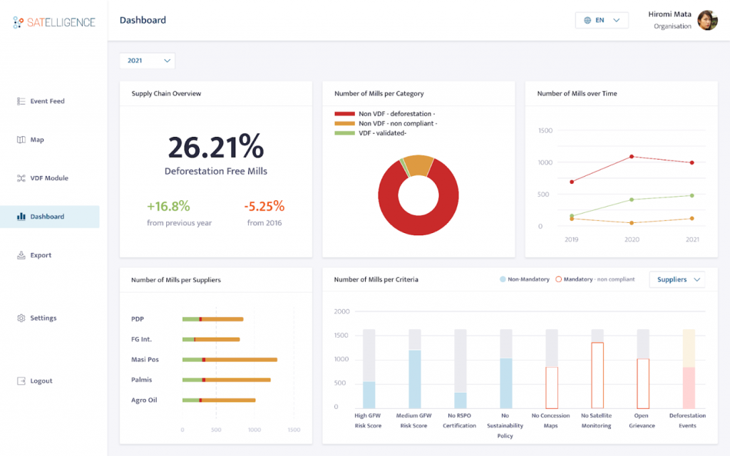
Example of Deepview’s palm oil dashboard for Aceh in Indonesia

“InCubed has enabled us to complete early testing of our solution across a wide cross section of companies and to drive our market introduction forward at a time when deforestation is garnering considerable international attention. We are very grateful to ESA and the Netherlands Space Office for their continuing support,” Nanne Tolsma adds.

The ESA Technical Officer for the activity is Frank Martin Seifert: “Deepview is a prime example of how Earth observation can be at the forefront of real-time environmental oversight while also forming the basis for value-added commercial applications. We’re happy to have provided InCubed funding for an initiative that is win-win-win: beneficial for the profile of EO, for industry and above all for the health of the planet.”

To know more: Satelligence, Copernicus, Deepview use case

InCubed and SENER Aeroespacial’s EO-DDL development continues apace

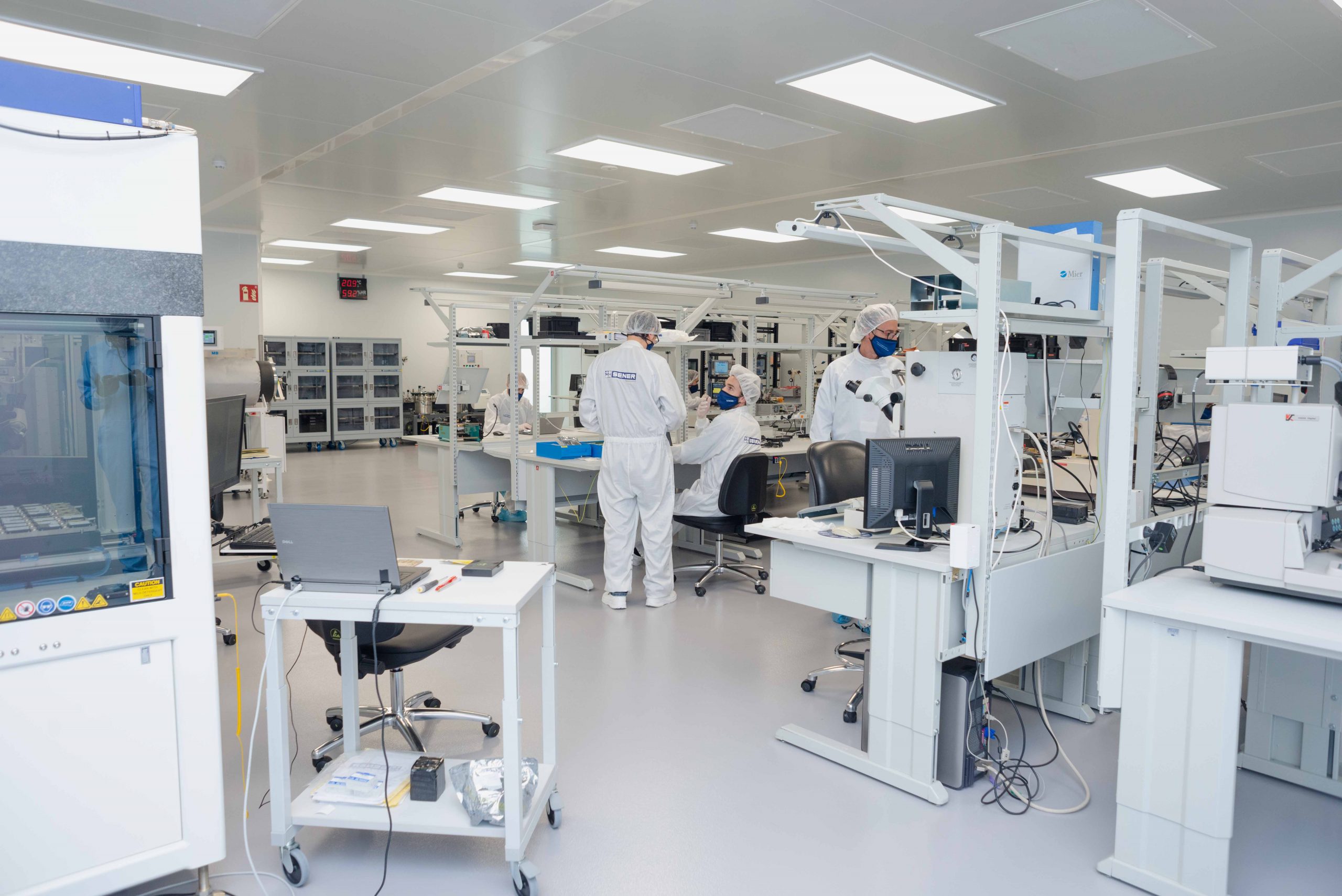
Eight months after kick off, the EO-DDL payload data transmission system is currently undergoing prototype construction. Designed to meet the downlink requirements of tomorrow’s Earth observation satellites, the InCubed co-funded activity is well on the way to reaching a key Technology Readiness Level milestone.

With the rapid transformation of the Earth observation sector, satellites are increasingly being launched in large constellations with payloads of next-generation sensors producing considerable volumes of data. This presents significant challenges for data transmission, as the growth in spacecraft numbers leads to congestion of frequency bands and current hardware struggles to keep up with payload data-rate requirements.

ESA has proposed to alleviate the problem of overcrowded airwaves by moving the frequency range for sensor data from the X-band (8.025-8.4 GHz) to the K-band (25.5-27 GHz). While the K-band has the advantage of a greater bandwidth, it does bring its own challenges, such as requiring highly directional beams and complex signal modulation to cope with the infamous ‘rain fade’ effect.

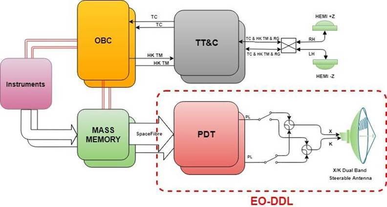
Responding to these trends and technical requirements, SENER Aeroespacial is developing a bespoke, future-proof solution for satellite-to-ground-station data transmission: the Earth Observation Data DownLink system (EO-DDL). The EO-DDL consists of a Payload Data Transmitter (PDT) unit in tandem with a Dual Band Steerable Antenna (DBSA) assembly. The system can transmit in both X and K-band and will handle data rates of over 2.6 Gb/s per channel.

Building on a feasibility study it previously carried out for ESA, SENER is now working under an InCubed contract to develop the product further. “Collaborating on this InCubed activity is an exciting opportunity for SENER, as it will enable us to meet the increasing demands for high-throughput LEO-to-ground communication in institutional and commercial EO markets. We’re very happy to contribute to cross-fertilisation within ESA by extending the experience we’ve gained in the Science Programme to Earth observation. We’re also hoping to agree strategic partnerships as a result of the development, with several satellite manufacturers already showing interest in the proposed product line,” commented Jose Antonio Gomez, SENER Project Manager for the EO-DDL.

Andrea Modenini, ESA Technical Officer, was also keen to underline the importance of the activity: “Developing the EO-DDL represents a major step forward in satellite communication architecture. The dual-band capabilities will provide unprecedented flexibility, while the data-rate capacity of multiple gigabits per second will ensure that the data transmission module can tackle the expected traffic from big-data payloads.”

Since signing the contract in March of this year, product development has been progressing steadily. Following the definition and design phase, the team successfully passed the Preliminary Design Review and will hold the all-important Critical Design Review within the next few weeks. Meanwhile the prototype components are being produced and assembled in preparation for functional testing, with the activity expected to meet its final objective of achieving a significant level of technology readiness (TRL 6) during the second quarter of 2022.

To know more: SENER Aeroespacial, ESA Technology Readiness Levels, Satellite frequency bands

Sat4Flood completes InCubed activity to monitor levees and is now in commercialisation phase

Miramap, SkyGeo and 52impact have successfully completed the Sat4Flood activity as part of the InCubed programme, demonstrating the ability to estimate and visualise the risks of levee failure using Earth observation data. Sat4Flood is now rolling out the product to water safety organisations and has started to generate revenue.

Sat4Flood provides organisations responsible for water safety with a cost effective tool to better understand and manage levee failure risks globally. Dutch activity partners Miramap, SkyGeo and 52impact developed the Sat4Flood monitoring service by combining satellite high-resolution soil moisture data with Interferometric SAR deformation data and other Earth observation data sources.

Since completing the InCubed activity, the Sat4Flood activity partners have started engaging with potential customers and rolling out the product commercially, beginning with water authorities and international engineering companies. As a result Sat4Flood is expected to soon join the ranks of former InCubed activities that are generating revenue.

Sat4Flood Project Manager Yvette Pluijmers from Miramap said: ‘’By combining our companies’ extensive experience in monitoring levees, we have been able to develop state-of-the-art technologies that can identify and monitor levee failures. The consequences of levee failure are huge and so Sat4Flood provides users with a much-needed product to help prevent the devastating impacts of levee failures.’’

Sea level rise, extreme weather such as hurricanes, storms and drought events around the world continue to cause levee failures. This can lead to critical flood defence failures resulting in tragic losses of life and the devastation of large areas. Sat4Flood service helps water safety organisations to prevent such failures by providing continuous and reliable monitoring of levees. The Sat4Flood service web portal provides information in a user-friendly way and potential levee hazard alerts are pushed to service users in order to proactively mitigate the risk.

ESA’s InCubed programme supported the development, validation and commercial viability of Sat4Flood. This included identifying key target customers, gathering their feedbacks on levee failures identification and visualisation to validate the product, up to engaging with three potential customers in a proof of concept validation. The proof of concept was a great success, the engaged customers received three months of fully operational service, to which they provided very useful feedback to further fine-tune the product.

Amanda Regan, Head of the Φ-lab Invest Office and InCubed Programme Manager, said: ‘’Sat4Flood provides water safety organisations with an invaluable product to monitor levee failures. The InCubed team have enjoyed working with Miramap, SkyGeo and 52impact to develop Sat4Flood and we wish them all the best in their commercial roll-out.’’

The Sat4Flood InCubed activity commenced in September 2019 and was successfully concluded during the final review in March 2021. A major finding of the activity was a clear confirmation of the benefits that satellite based systems like Sat4Flood can provide to users with customisable levee monitoring information.

To know more: Sat4Flood InCubed activity, Sat4Flood website, Sat4Flood video pitch

HubCAP kicked-off as a new InCubed activity

HubCAP is a newly launched product developed by the Irish Icon Group with the support of ESA InCubed programme. This Open Source “Hands-Free Monitoring” platform for integration with existing workflows will answer the emerging needs from ELMS/CAP (environmental land management system/common agriculture policy), which represent a deep interest for the Icon Group.

HubCAP will be a highly flexible Application Platform for the agriculture and environmental sectors, based on Copernicus data and the SEN4CAP (Sentinels for Common Agriculture Policy) toolkit. It is developed by the Icon Group, a European leader in Earth imaging services and Ireland’s largest processor of imagery data.

The objective of this newly developed product is to align with a new paradigm in Land Cover and Use Determination using satellite imagery that has been enabled by the move from an artisanal process to an automated workflow-based provision of information. This will free up trained and capable technicians to provide analysis and information, rather than just simple image-based products, making the end user experience easier and more tailor-made.

The HubCAP service is conceived as three modules, each with a different starting point:

  1. IACS Module (integrated administration and control system)  – this will be the Paying Agency existing interface for CAP users, which they will customise to obtain HubCAP information
  2. EO Module – based upon results of other activities (SEN4CAP, DIAS (Data and Information Access Services))
  3. Bureau Module – based on a validated user concept and other activities (IACS)

The system is simple – because it includes a comprehensive API (Application Programming Interface) for monitoring via direct integration with existing administration systems, wide, verified, fully supported and very customer focused. It is wide thanks to an advanced dashboard for conducting bespoke ad-hoc local analyses, and it is verified since it offers and supports integrated ‘geo-photos’ and other forms of verification, where required.

Also, each classification ‘transaction’ is fully recorded and certified, showing the algorithm version and image sets used.

Elaine Doyle, Icon Group Product Manager said: “HubCAP is a robust and simple platform through which Government Agencies (especially CAP, non-CAP Paying Agencies and Environmental Agencies), and commercial users will be able to access the benefits of Sentinel data in a fully supported, legally recorded and compliant manner. We are very happy to count on ESA InCubed programme support to develop and commercialise it”.

Patrick Griffith, ESA Technical Officer, added: “The market of EO based CAP monitoring service capabilities is now really taking up pace. HubCAP comes with some innovative concepts and will lead to the enrichment and diversification of this key market for EO services.”

To know more: HubCAP Activity page, Icon Group, ESA InCubed programme

Φ-lab visiting professor advances the application of quantum computing in EO

Prof. Mihai Datcu, Visiting Professor at Φ-lab, has recently published a paper on the use of Quantum Computing in hyperspectral imaging, a compelling and topical area which is very much in line with the QC4EO initiative. The paper is included in the prestigious IEEE J-STARS journal and describes the first application of a quantum annealer in EO data analysis.

Quantum technologies are constantly evolving, with Quantum Computing (QC) enjoying fast-track development and considerable investment within the ICT industry. The Quantum Computing for Earth Observation (QC4EO) initiative is one of Φ-lab’s flagship programmes, aimed at exploring new computing paradigms to solve previously intractable data-analysis problems in EO.

Initially created as a collaborative venture between ESA and CERN, QC4EO now has a number of partners including DLR, ECMWF, ELLIS, LRZ and TUM. The initiative seeks to leverage the increasing power of quantum computers to explore new EO applications. Some of the potential of QC4EO lies in the intersection of EO problems with QC’s capabilities for optimising large-scale systems and Quantum Machine Learning (QML).

One of the most interesting applications is the processing of images from hyperspectral satellite sensors. The substantial volumes of data from the HYP image sensors are organised in a number of spectral bands, but not all the bands have the same information value for the classification of features such as land cover types. Prof. Datcu explains: “Selecting the most informative and trustworthy bands for each land-cover class is an important analysis step for high-accuracy classification tasks and saving internal storage space. Although there are conventional computational tools for this selection process, known as annealers, we knew from theoretical studies that quantum technologies have the potential to carry out the optimisation more efficiently. Until now though, there hasn’t been any real-world research in this area.”

Prof. Datcu’s work involved comparing the performance of quantum and traditional computational techniques in processing the hyperspectral data. First, a D-Wave Quantum Annealer (D-Wave QA) was benchmarked against a conventional annealer for the task of band selection. Next, the D-Wave QA-selected bands were split into the respective land-cover classes with both quantum and conventional classifiers.

The results were encouraging: “In the first part of the study, we proved that the D-Wave QA selected the appropriate bands and that the quantum methodology reduced both storage space and computational load,” Prof. Datcu comments. “In the case of the classifiers, the quantum versions even outperformed their conventional counterparts in most instances.”

Leading on from the success of the study, Prof. Datcu’s future work at QC4EO will develop the concept of a hybrid quantum-classical network for EO datasets, creating a tool that can operate across a range of dataset types and sizes.

When asked about this and other collaborative research he is working on at ESA, Prof. Datcu is decidedly enthusiastic: “Φ-lab is a fantastic opportunity to study interdisciplinary, highly complex EO activities such as mission design, remote sensing, environmental parameter retrieval and the interpretation of calibrated results. I see my job as putting together a new vision of AI4EO [Artificial Intelligence for Earth Observation], and inevitably the promising resources of quantum computing will play a major part in that.”

The full paper, A Quantum Annealer for Subset Feature Selection and the Classification of Hyperspectral Images by Soronzonbold Otgonbaatar and Mihai Datcu, can be found here. Other recent papers co-authored by Prof. Datcu include:

  • S. Otgonbaatar and M. Datcu, Natural Embedding of the Stokes Parameters of Polarimetric Synthetic Aperture Radar Images in a Gate-Based Quantum Computer, in IEEE Transactions on Geoscience and Remote Sensing, DOI: 10.1109/TGRS.2021.3110056, downloadable here
  • S. Otgonbaatar and M. Datcu, Classification of Remote Sensing Images With Parameterised Quantum Gates, in IEEE Geoscience and Remote Sensing Letters, DOI: 10.1109/LGRS.2021.3108014

To know more: QC4EOΦ-lab Flagship Programmes

Living Planet Symposium 2022: time for abstracts

ESA’s next Living Planet Symposium is set to take place on 23–27 May 2022 in Bonn, Germany. In gearing up for this prestigious event, it’s now time to submit abstracts to ensure a much sought-after slot to present topics such as the latest scientific findings on our planet, novel Earth observing technologies and new opportunities emerging in the rapidly changing sector of Earth observation.

The deadline for abstract submission is 26 November 2021.

The Living Planet Symposia bring together scientists and researchers from all over the world to present and discuss the latest findings on Earth science and advances in Earth observation technologies. Moreover, these extraordinary events also offer unique forums for decision-makers to be better equipped with information, for partnerships to be forged and formalised, for space industries to join the conversation, for students to learn, and for all to explore the concepts of New Space such as the digital transformation and commercialisation.

Read the full article on www.esa.int

Deep Property by Ticinum Aerospace: InCubed support boosts an innovative AI-based service

Under the ESA InCubed programme, the Italian company Ticinum Aerospace will develop an innovative solution in the various areas of the insurance business (e.g. underwriting, risk modelling, etc.) by leveraging Deep Property. This AI-based service is capable to provide high-quality property data derived from geospatial sources in a cloud-based environment.

Ticinum Aerospace is a spinoff company from the University of Pavia, Italy, founded in 2014 by PhD students and PostDocs at the FabSpace Lab. Their expertise is in Artificial Intelligence (AI), machine learning, computer vision techniques and geospatial data processing.

Ticinum Aerospace aims to scale up a service called Deep Property using an AI-based approach to identify and record risk-relevant characteristics of individual buildings, such as the number of floors, the year of construction, the materials used, etc. This technology leverages big data derived from satellites, Earth observation techniques and other hi-tech sources (e.g. street-level images, smartphone pictures, etc.) to generate information layers that will reduce uncertainty in large-scale risk scenario evaluations.

The use of high-quality property data, generated in near-real-time, will enable insurance and risk modelling companies to enable their clients to improve risk mapping and more efficient property risk management. This will result in reduced losses and, at the same time, increasing competitiveness on the market. This concept originated in the risk estimation context, the generated property data, is coveted in other businesses, like real estate, energy, and smart cities.

The Deep Property development was kicked off in June 2021. All companies supported by the European Space Agency’s Investing in Industrial Innovation (InCubed) programme receive co-funding, technical and strategic support to further develop the service. Before the end of InCubed support in December 2022, Ticinum Aerospace primarily aims to develop new satellite data-based models, improving speed performances, and enlarging the pool of customers by better understanding their needs. During the development, Deep Property will be supported by two leading companies in the insurance context: Generali Global Corporate and Commercial, and Willis Tower Watson.

Gianni Cristian Iannelli, Ticinum Aerospace CEO and Head of Deep Property development team, said: “We are so glad for the opportunity InCubed programme is giving us, and we will do our best to meet the expectation that Deep Property is set to achieve success at global scale. For us as a group of engineers, ESA has always been a source of inspiration, and we are all excited to get their support in our next actions. Deep Property‘s mission is cutting the cost of risk uncertainties, especially against the effect of climate change. ESA will be a valuable partner in reaching our mission on making cities more resilient to natural disasters”.

Michele Castorina, ESA Technical Officer, also added: “More and more data from commercial Earth observation satellites is becoming available at prices that allows downstream market to flourish. Deep Property is exploiting the availability of this data through innovative machine learning algorithms for the insurance market, bringing value and innovation in a sector that is actively seeking to meet the challenges brought by the digital transformation. As ESA InCubed programme, we are more than happy to support this process. ”

To know more: Deep Property, Ticinum Aerospace, Willis Tower Watson, Willis Tower Watson Press Release, Generali, Generali Press Release

Φ-week 2021: looking back and looking ahead

With thousands of online participants and more key sessions than ever before, Φ-week 2021 has proven to be a great success. As the curtain comes down on the event, now is a good time to reflect on its significance, take a quick tour of some of the hugely rich content, and think about outcomes and aspirations.

“Φ-week has established itself as the essential barometer for gauging the current status and future direction of EO innovation – and the 2021 edition is no exception. The coming together of industry, academia, private investors and major institutions fosters a unique exchange of ideas that invigorates our sector and propels us forward” – Giuseppe Borghi, Head of the Φ-lab and member of the Φ-week organising committee.

This year’s Φ-week got off to a tantalising start, with ESA Director General Josef Aschbacher announcing a competition – promising funding worth a total combined value of €1 million – in the areas of cognitive cloud computing in space. Innovators, researchers and entrepreneurs looking to submit their proposals for the competition will have found a great deal to stir the imagination from the 17 main sessions and around 190 supplementary items throughout the week. Indeed Artificial Intelligence (AI) and advanced computing paradigms were frequently recurring topics, with dedicated key sessions and a number of side events devoted to the application of this area to EO.

There were over 3,800 registered attendees from 91 countries at Φ-week 2021. For Ville Meskus, another organising committee member, the gathering provides a vital stimulus for the sector: “Φ-week gives our growing community a unique opportunity to get a very quick, yet comprehensive, snapshot of the latest developments in space and digital technologies, along with their potential and strengths and weaknesses. From my conversations with participants, I know they benefit hugely from the discussions and diversity of material presented, leaving them brimming with inspiration.”

The event this year, now in its fourth edition, was focused on EO New Space, and the theme was covered comprehensively over the course of the five days. Key sessions took up the subjects of enabling technologies, European access to space and accelerating New Space uptake. Smallsats were also discussed in detail, including both ESA SCOUT and other EO missions based on CubeSat platforms.

Many of the side events were hosted by external organisations. Running throughout the week, these specialised sessions delved into an extremely broad range of EO-related subjects, including the Space App Camp, Rapid Action on COVID19 with EO (RACE), data quality, intellectual property and AI for InsurTech, to name but a few.

The e-exhibitions and e-posters mirrored the themes of the key sessions, with around 150 organisations displaying their wares to the virtual audience. Attendees expressed their appreciation at the chance to network, chat via instant messaging and even organise individual video calls with exhibitors.

Looking to the future, Head of the Φ-lab Explore Office Pierre Philippe Mathieu hopes that Φ-week will also attract some new players to the scene, both in terms of careers and the funding competition: “As we’ve seen this week, space is an enthralling and promising career option, and in fact we have positions open in Φ-lab for Research Fellows to explore areas such as AI, the Internet of Things and Quantum Computing for EO. The competition announcement, which is particularly close to our hearts in Φ-lab, will undoubtedly engender a host of fresh ideas for exploring how cognitive cloud computing in space can help shape the new generation of software-defined missions. By next year’s Φ-week, we’ll know who has risen to the Director General’s challenge and whose concepts have won the sought-after funding.”

To know more: Φ-week, ideas.esa.int, jobs.esa.int, Contact Φ-lab